RITORD (VS)
Historical glacier forefield
Elevation: 2490-3000m - Massif: Valais Alps (Grand-Combin) - Commune: Bourg-Saint-Pierre (VS)
The study site consists of the historical glacier forefield at the confluence of the Ritord and the Epée glaciers at the foot of the western slopes of the Maisons Blanches. It features a complex morphology: remnants of a covered glacier, a push moraine (body of frozen sediments that were pushed, dragged and deformed by the advancing glacier during the Little Ice Age), rock glaciers, etc. The Ritord glacier will soon have completely disappeared, while the covered tongue of the Epée glacier still lies to a great extent within its boundaries of the Little Ice Age, however being much thiner. The push moraines are still frozen at depth. On the outside of the proglacial margin, sometimes in direct contact with the latter, many rock glaciers can be found; some of which are active (motion rate of up to several tens of centimeters per year). First observations started in 1997 (geoelectrical and thermal).
-
Measurements and observations
Thermal (ground surface temperature : GST)
Geophysics (electrical resistivity) -
Figures
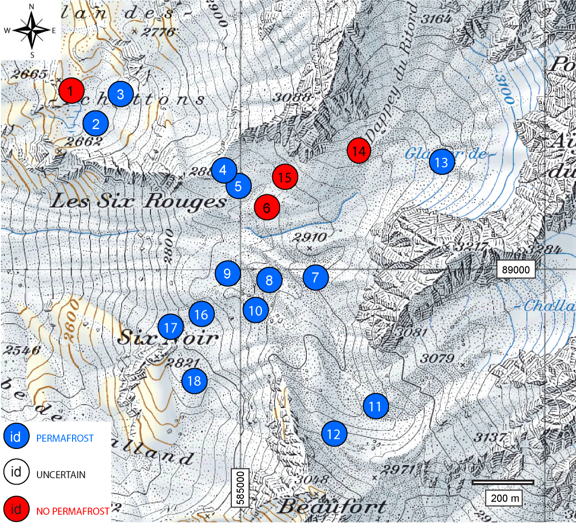
Occurence/absence of permafrost (locally debris-covered glacier) based on electrical resistivity measurements (data: 1997).
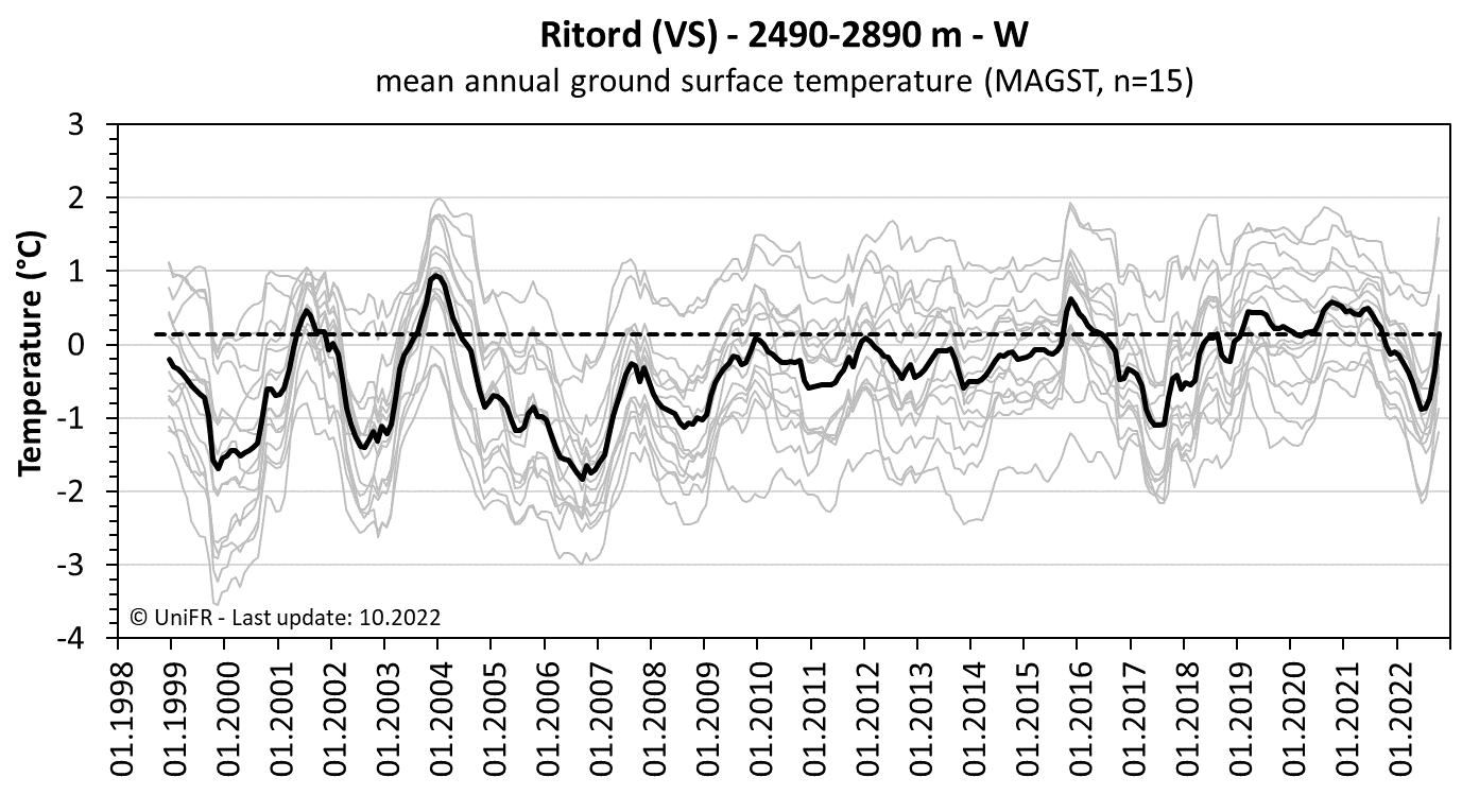
Mean annual ground surface temperature. The orange curve represents the mean temperature of the n sensors installed on the site (grey curves). The orange dotted line is the mean temperature observed on the site since the beginning of the measurements.
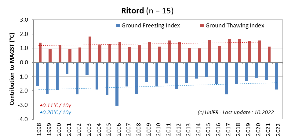
Contribution of the annual Ground Freezing (sum of all daily mean values < 0°C) and Ground Thawing (>0°C) Indexes to the mean annual ground surface temperature (MAGST) on a set of selected locations (n) on the site with indication of the respective trend since the beginning of the time series. Or : how cold was the winter and how warm was the summer at the surface of the ground ?
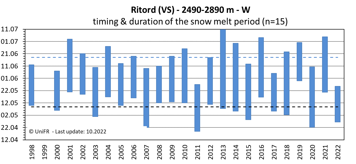
Annual dates of the start and end of the snowmelt period (zero curtain phase). Mean of n sensors placed on permafrost terrain. The dotted lines show the mean dates since the beginning of the time series.
-
Collaboration
-
Publications
Delaloye, R., Lambiel, C. (2008). Typology of vertical electrical soundings for permafrost/ground ice investigation in the forefields of small alpine glaciers. In : Hauck, C., Kneisel, C. (eds), Applied Geophysics in Periglacial Environments, Cambridge University Press, 101-108. (pdf)
Delaloye, R. (2004). Contribution à l’étude du pergélisol de montagne en zone marginale. PhD thesis, Fac. Sciences, Univ. Fribourg, GeoFocus 10 (pdf)
Delaloye, R., Lambiel, C., Reynard E. & Lugon R. (2003). Réponse du pergélisol à l’avancée glaciaire du petit âge glaciaire : quelques exemples alpins et pyrénéens. Environnements Périglaciaires 10.
Delaloye, R., Devaud, G. (2000). La distribution du pergélisol dans les marges proglaciaires des glaciers de Challand, d’Aget et du Sanetschhorn (Valais, Alpes suisses). HEGG, CH., VONDER MÜHLL, D. (Hrsg.) : Beiträge zur Geomorphologie. Proceedings der Fachtagung der Schweizerischen Geomorphologischen Gesellschaft vom 8.-10. Juli 1999 in Bramois (Kt. Wallis). Birmensdorf, Eidgenössischen Forschungsanstalt WSL, 89-96.