LAPIRES (VS)
Talus slope, active rock glacier
Elevation: 2360-2650 m - Massif: Valais Alps (Mont-Gelé) - Commune: Nendaz (VS)
The scree slope of Lapires is a massive detritic post-glacial accumulation, in some place up to 40 m thick. It is the result of the still ongoing erosion of the Pointe des Lapires. The permafrost distribution within the scree slope is heterogeneous, which is partly linked to intra-scree air circulation effect. Hence, ground temperatures are lowest within the lower half of the slope. Permafrost was detected locally down to a depth of 20 meters. In the higher section of the scree slope a small active rock glacier moves at a speed of 50 cm to more than one meter per year. First investigations (thermal and geophysical) were carried out at the opportunity of the reconditioning works of the Tortin-Chassoure cable car in 1998. Most of the measurements have been done surrounding the pylon P10, which is located in the middle of the talus slope. A few temperature sensors have been installed between 2004 and 2013 within the surrounding rock walls. This site is integrated into the “Kinematics” and “Temperature” sections of the PERMOS (PERmafrost MOnitoring in Switzerland) network.
The analysis of satellite radar interferometry data has shown that all the Lapires region had suffered little subsidence and heave motion caused by the drilling and the subsequent semi-waterproofing of a water duct of the Cleuson-Dixence hydropower scheme between 1995 and 1999.
-
Measurements and observations
Thermal (boreholes, ground surface temperature : GST, BTS)
Geophysics (electrical resistivity, permanent ERT profiles, refraction seismic)
Geodetic (GNSS)
Weather station
Webcam -
Figures
Webcam Lapires: current image.
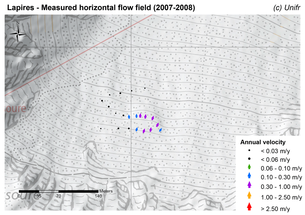
Measured horizontal flow field (mean annual velocity).
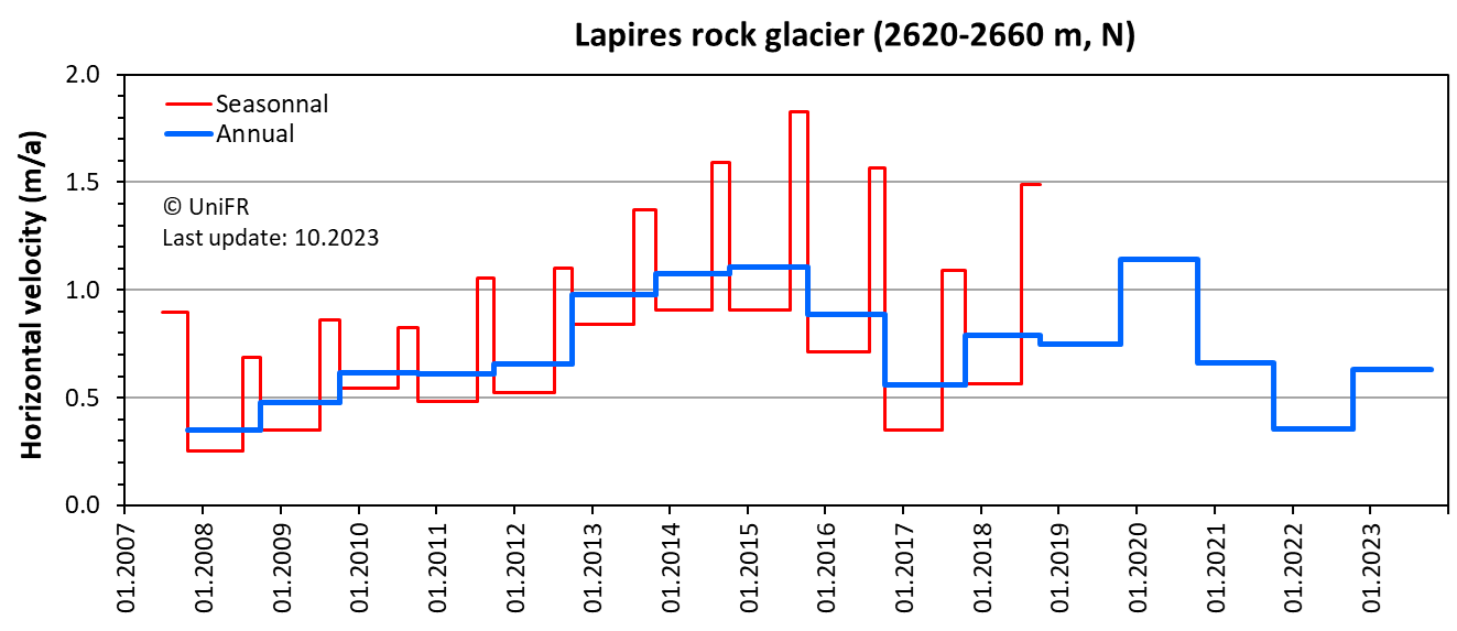
Annual and seasonnal horizontal surface velocity. Mean of a set of points selected in the most active part of the rock glacier.
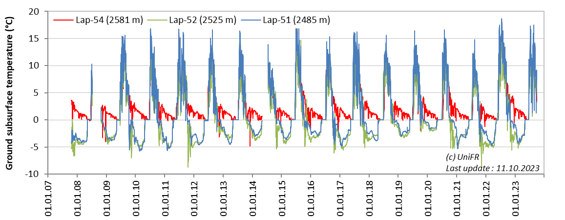
Daily ground surface temperature (GST) at three locations along a longitudinal profile in the vicinity of pylon P10.
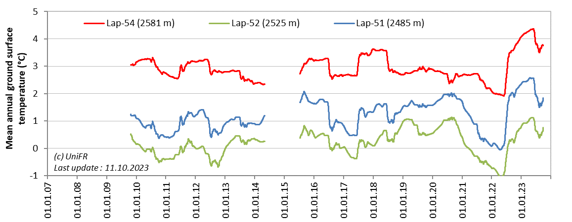
Mean annual ground surface temperature (MAGST) at three locations along a longitudinal profile in the vicinity of pylon P10.
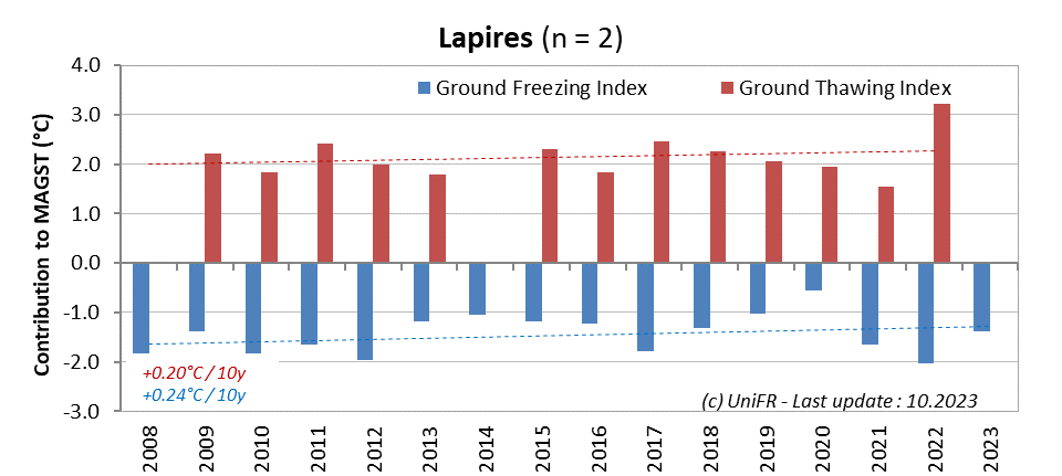
Annual ground freezing and thawing indices (calculated during the hydrological year) with indication of the respective trend since the beginning of the time series. Mean of the n sensors installed on the site.
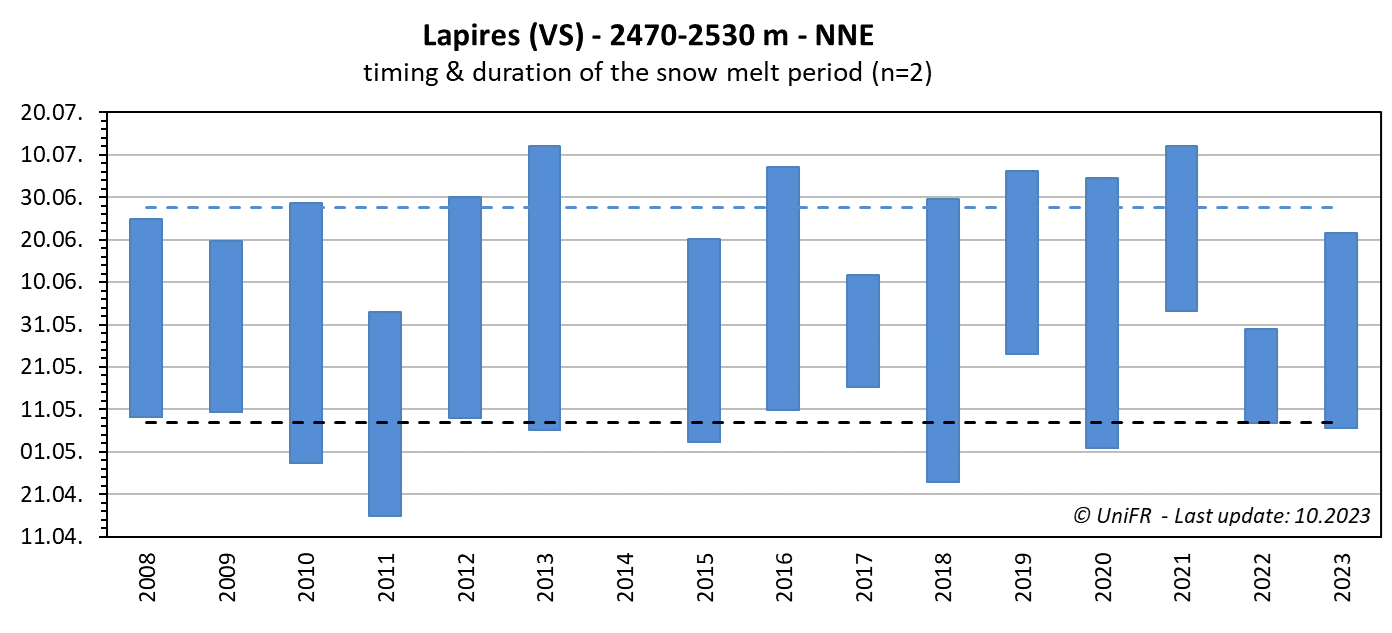
Annual dates of the start and end of the snowmelt period (zero curtain phase). Mean of n sensors placed on permafrost terrain. The dotted lines show the mean dates since the beginning of the time series.
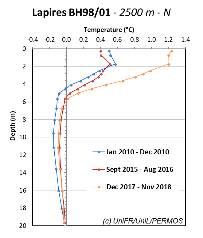
Recent mean annual thermal profiles in the borehole BH98_01 close to the pylon P10.
.png)
Early winter cooling: thermal profiles measured on January 1st in the upper section of borehole BH98_01 close to the pylon P10 since 1999.
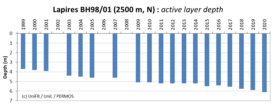
Maximal thickness of the active layer (summer thaw) in the borehole BH98_01.
.png)
Selected of thermal profiles measured on November 1st in the borehole BH08_12 about 50 m upslope of pylon P10.
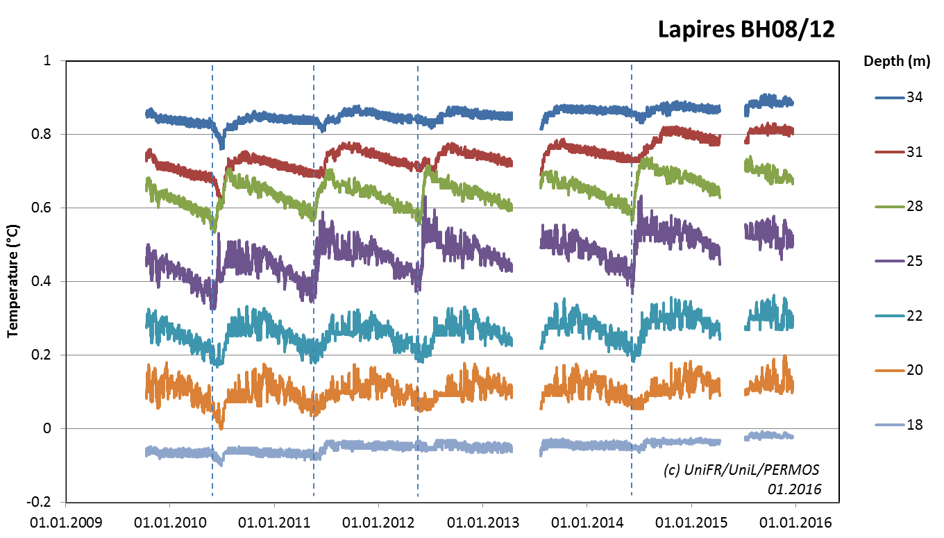
Multiannual behavior of the temperature close to the permafrost base (20 m) and deeper within the porous talus slope crossed by borehole BH08_12 : combined influence of water (particularly in early summer) and air flow (all the year along).
-
Collaboration
University of Lausanne, Institute of Earth Surface Dynamics (C. Lambiel)
Televerbier, Telenendaz
ID electronic SA
Meteodat GmbH
SensAlpin GmbH
Waljag GmbH -
Publications
Mollaret, C., Hilbich, C., Pellet, C., Flores-Orozco, A., Delaloye, R., Hauck, C. (2019). Mountain permafrost degradation documented through a network of permanent electrical resistivity tomography sites. The Cryosphere, 13, 2557–2578, DOI : 10.5194/tc-13-2557-2019.
PERMOS 2019. Permafrost in Switzerland 2014/2015 to 2017/2018. Noetzli, J., Pellet, C., and Staub, B. (eds.), Glaciological Report (Permafrost) No. 16-19 of the Cryospheric Commission of the Swiss Academy of Sciences, 104 pp, DOI:10.13093/permos-rep-2019-16-19.
PERMOS (2016). Permafrost in Switzerland 2010/2011 to 2013/2014. Noetzli, J., Luethi, R., and Staub, B. (eds.), Glaciological Report (Permafrost) No. 12-15 of the Cryospheric Commission of the Swiss Academy of Sciences, 85 pp. (pdf)
Staub, B., Marmy, A., Hauck, C., Hilbich, C., and Delaloye, R. (2015): Ground temperature variations in a talus slope influenced by permafrost: a comparison of field observations and model simulations, Geogr. Helv., 70, 45-62, doi:10.5194/gh-70-45-2015.
Scapozza, C. (2013). Stratigraphie, morphodynamique, paléoenvironnements des terrains sédimentaires meubles à forte déclivité du domaine périglaciaire alpin. Géovisions 40. Institut de géographie et durabilité Faculté des Géosciences et de l'Environnement Université de Lausanne CH-1015 Lausanne, Switzerland: Université de Lausanne, Institut de géographie et durabilité. ISBN 978-2-940368-16-7.
PERMOS (2013). Permafrost in Switzerland 2008/2009 and 2009/2010. Noetzli, J. (ed.), Glaciological Report (Permafrost) No. 10/11 of the Cryospheric Commission of the Swiss Academy of Sciences, 80 pp. (pdf)
Strozzi, T., Delaloye, R., Poffet, D., Hansmann, J. and Loew, S. (2011). Surface subsidence and uplift above a headrace tunnel in metamorphic basement rocks of the Swiss Alps as detected by satellite SAR interferometry. Remote Sensing of Environment 115, 1353–1360. DOI : 10.1016/j.rse.2011.02.001
Hilbich, C., Hauck, C., Delaloye, R., Hoelzle, M. (2008). A geoelectric monitoring network and resistivity-temperature relationships of different mountain permafrost sites in the Swiss Alps. Proceedings of the Ninth International Conference on Permafrost, July 2008, Fairbanks, Alaska, 1, 699-704.
Lambiel C. (2006). Le pergélisol dans les terrains sédimentaires à forte déclivité: distribution, régime thermique et instabilités., Université de Lausanne, Faculté des géosciences et de l'environnement, Winistörfer J. (dir.), 260 p.
Delaloye, R., Lambiel, C. (2005). Evidence of winter ascending air circulation throughout talus slopes and rock glaciers situated in the lower belt of alpine discontinuous permafrost (Swiss Alps). Norwegian Journal of Geography. Vol. 59/2, 194-203. DOI: 10.1080/00291950510020673
Bardou, E. & Delaloye, R. (2004). Effects of ground freezing and snow avalanche deposits on debris flows in alpine environments. Natural Hazards and Earth System Science, Vol. 4, pp 519-530. DOI : 10.5194/nhess-4-519-2004
Delaloye, R. (2004). Contribution à l’étude du pergélisol de montagne en zone marginale. PhD thesis, Fac. Sciences, Univ. Fribourg, GeoFocus 10 (pdf)
Marescot, L., Loke, M. H., Chapellier, D., Delaloye, R., Lambiel, C. and Reynard, E. (2003). Assessing reliability of 2D resistivity imaging in permafrost and rock glacier studies using the depth of investigation index method. Near Surface Geophysics, 1, 57-67. DOI: 10.3997/1873-0604.2002007. (pdf)