MOOSFLUH (VS)
Deep-seated landslide
Elevation: 1800-2200m - Massif: Bernese Alps (Aletsch) - Commune: Riederalp (VS)
Very large deep-seated landslide related to the slope debutressing (release of pressure) consecutive to the retreat of the Aletsch glacier. The landslide is an old feature dating back possibly to the end of the Late Glacial or the early Holocene, whose detailed rhythm of activity is unknown. After having moved about 1 cm/year since the end of the 1970s, an acceleration of the motion rate (and the occurrence of the landslide itself) up to more than 10 cm/year was detected by satellite remote sensing data (SAR interferometry) in the mid-2000s. Our in situ GNSS survey was launched in 2007. The landslide suffered an extraordinary peak activity in 2016-2017.
-
Measurements and observations
Geodetic (GNSS)
-
Figures
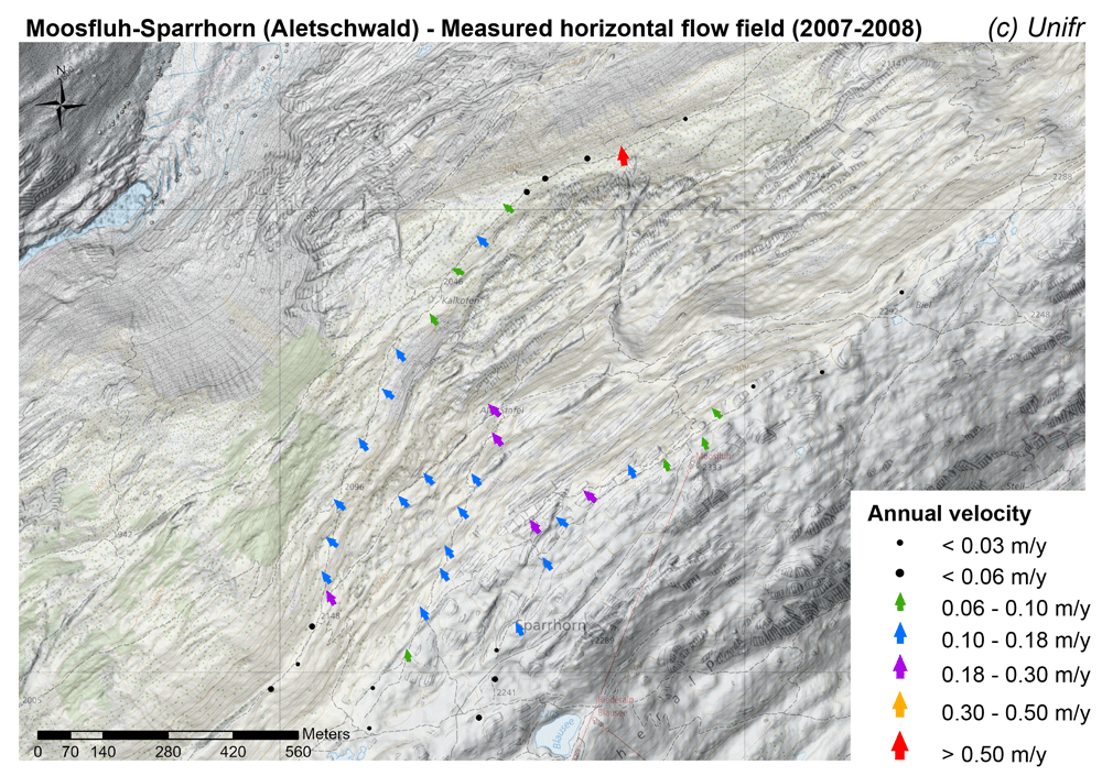
Measured horizontal flow field (mean annual velocity).
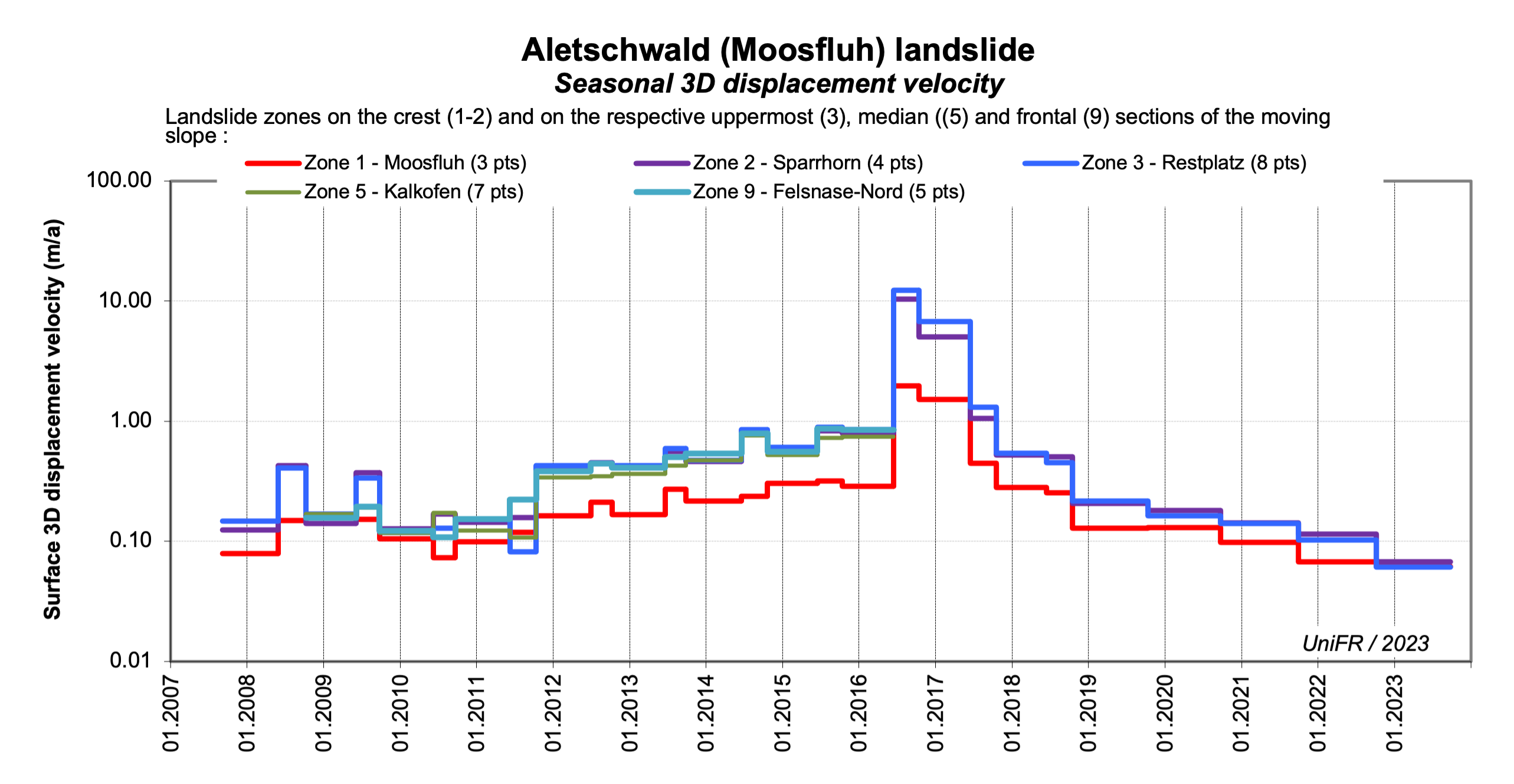
Seasonal 3D surface velocity. Mean of a set of points in the selected parts of the landslide. The median and terminal sections of the landslide are no more surveyed since 2016.
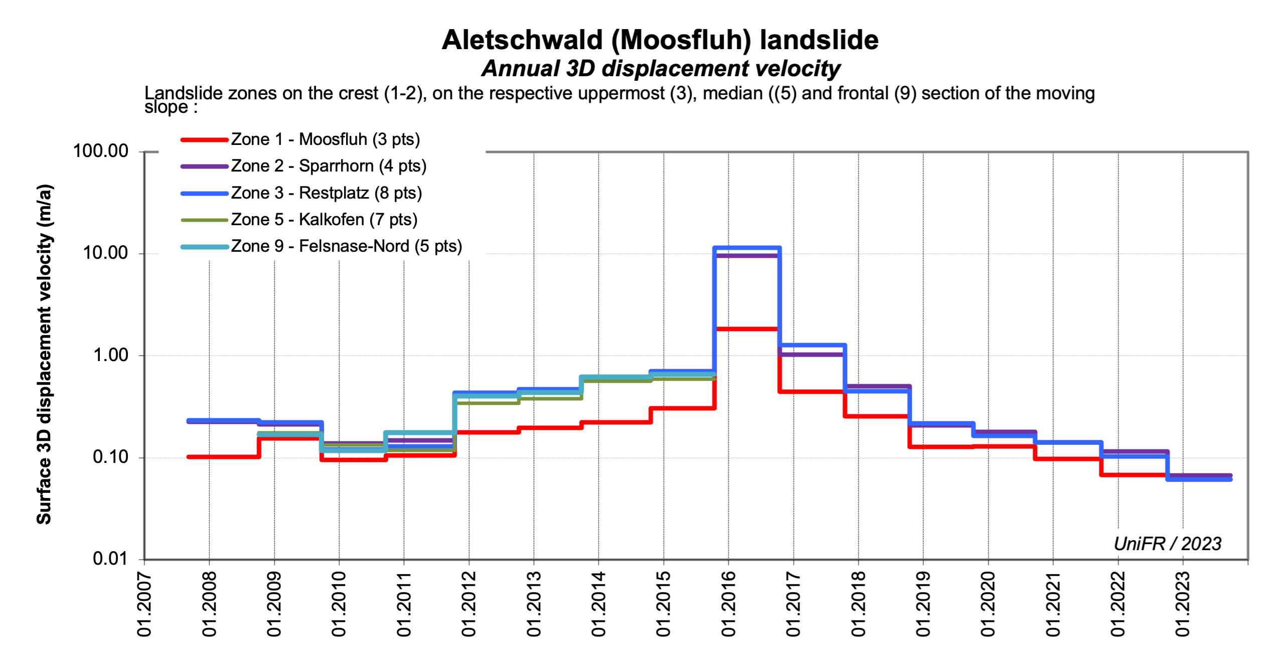
Annual 3D surface velocity. Mean of a set of points in the selected parts of the landslide. The median and terminal sections of the landslide are no more surveyed since 2016.
-
Collaboration
Geosat SA
Many further measurements are undertaken since 2016 (or earlier) by various actors. They are coordinated in particular by the Canton of Valais (Dienststelle für Wald, Flussbau und Landschaft - DWFL).
-
Publications
Kos, A., F. Amann, T. Strozzi, R. Delaloye, J. von Ruette, and S. Springman (2016). Contemporary glacier retreat triggers a rapid landslide response, Great Aletsch Glacier, Switzerland, Geophys. Res. Lett., 43, doi:10.1002/2016GL071708.
Strozzi, T., Delaloye, R., Kääb, A., Ambrosi, C., Perruchoud, E.and Wegmuller, U. (2010). Combined observations of rock mass movements using satellite SAR interferometry, differential GPS, airborne digital photogrammetry, and airborne photography interpretation. J. Geophys. Res., 115, F01014. DOI:10.1029/2009JF001311.
Strozzi, T., Wegmüller, U., Perruchoud, E., Delaloye, R., Kääb, A., Ambrosi, C. (2008). Evolution of a deep-seated rock mass movement observed with satellite SAR interferometry. Proceedings of the FRINGE 2007 Workshop, Frascati, Italy, 26-30 November 2007. (ESA SP-649, February 2008) (pdf)