Geophysical monitoring and joint inversion for permafrost studies
A better understanding of current mountain permafrost degradation implies a temporal and spatial permafrost distribution monitoring. Geophysical methods are widely used to explore the subsurface, as they are cost-efficient and do not disturb the ground. In this project, Electrical Resistivity Tomography (ERT) and Refraction Seismic Tomography (RST) are jointly used to investigate mountain permafrost at several sites in Switzerland. Indeed electrical resistivity and P-wave velocity discriminate between ice and water by several orders of magnitude. Mountain permafrost degradation was documented thanks to an alpine network of ERT monitoring sites (Mollaret et al., 2018).
Borehole temperature record and geophysical measurements are complementary, as temperatures give no information about ice content. The ice and water contents are estimated from the geophysical measurements through the four-phase-model (Hauck et al., 2011). A long-term geophysical monitoring is essential to interpret current and future mountain cryosphere evolution.
A new joint inversion scheme of apparent electrical resistivity and P-wave traveltimes (part of a collaboration with Florian Wagner, University of Bonn, Germany) is developed with the objective to quantify ground ice and water contents and to estimate porosity at the same time within the joint inversion approach.
Aims:
- Improvement of geoelectrical and seismic data acquisition and data processing for continuous monitoring of permafrost thaw processes in alpine and polar areas
- Joint/coupled data processing and joint inversion schemes for thermal and geophysical data sets
- Quantitative approaches to estimate ground ice contents and their temporal changes
- Relation of the obtained ice content changes to hydrological and kinematic processes in permafrost terrain.
Methods: Electrical Resistivity Tomography (ERT) and Refraction Seismic Tomography (RST), automatic weather station, borehole temperature. This project aims to develop a petrophysical joint inversion scheme of ERT and RST for permafrost applications
Study area: A variety of different permafrost sites in the Swiss and Italian Alps as well as in the Central Andes of Chile.
-
Illustrations
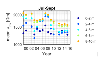
Figure 1 Averaged resistivity for several depth layers in summer months (July until September) at Schilthorn every year since 1999.
Colors represent depth layers. For the depth layers between 6 and 10 m depth, we can observe a first drop in 2003 (heatwave). Resistivity recovered to previous values in 2007. Since then, resistivity decreased below 6 m depth. It leads to the conclusion that more water is present at depth (between 6 and 10 m) also meaning a lower ice content.
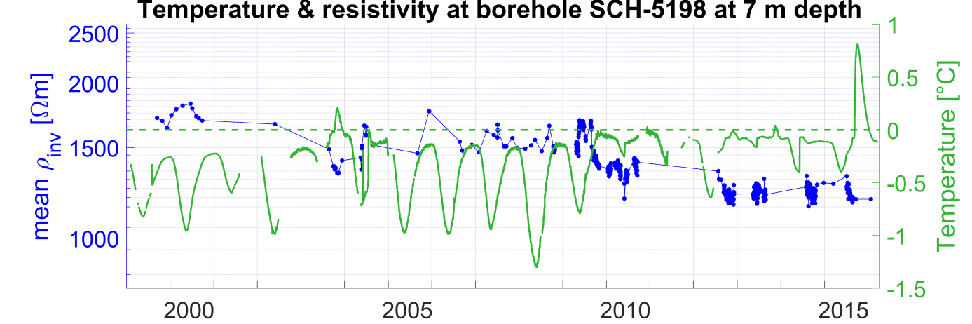
Figure 2 Borehole temperature and resistivity at 7 m depth at Schilthorn.
The higher the temperature, the lower the resistivity. When temperature get close to melting point, soil resistivity drop (in 2003 and in 2010). Since 2010, the resistivity kept very low indicating that the water content (at 7m depth around the borehole) stayed high (and consequently, ice content did not recover since 2010).
-
Publications
-
Hauck, C., Böttcher, M. and Maurer, H. (2011): A new model for estimating subsurface ice content based on combined electrical and seismic data sets. The Cryosphere, 5, 453–468.
-
Mollaret, C., Hilbich, C., Pellet, C., Flores-Orozco, A., Delaloye, R., and Hauck, C.: Mountain permafrost degradation documented through a network of permanent electrical resistivity tomography sites, The Cryosphere Discuss., https://doi.org/10.5194/tc-2018-272, in review, 2018.